This introduction continues with a brief description of forecast verification in very general terms. Following in Section 2 is a brief description of the automated phase error calculation procedure. Section 3 briefly describes a specific application of the procedure.
In general, any forecast verification procedure may be thought of as some operator V acting on a forecast f and its verifying observed values o yielding one or more values to be operated upon by some normalizing or score generating function E to give the final value or vector of values s:
For example, in the case of bias, V(f,o)=f-o, and E is the averaging operator (summation, followed by dividing by the number summed). Although s is presented here as the composition of two functions, E and V. It is often the case that both E and V are themselves composite functions, the division of mathematical labor between E and V may sometimes be chosen arbitrarily for the convenience of the problem under consideration and the method of data storage and processing. In general, the first function of which V is composed must be some transformation applied in the same way to both the verifying observations and the forecast values and a comparison operator of some sort. This may be expressed as T(f)~T(o), where T represents the transformation and ~ represents the operator. In the example of bias, T is the identity transformation and ~ is the subtraction operator.
This general description of the verification process is presented in this way to show that considerable creativity may be expressed in the design of these procedures. As long as the same thing is done to both the forecast and observed or analyzed values, it is possible to compute a measure of forecast verification that has validity. The usefulness of the measure to forecasters depends upon how well it can be related to factors that are considered during the forecasting process itself.
The phase errors represent east/west displacements of the forecast relative to the analysis within zonal bands. Actual phase errors often have north/south components, and would, therefore, be larger in magnitude than represented by this approach. Future development will extend this method to two dimensions to determine a field of vector phase errors. In the future approach, the gradient of the forecast difference field will provide the basis for determining the direction of the phase error vector; while, its magnitude will be determined using the method outlined above applied in a zonal strip constructed in a latitude longitude coordinate system rotated to align with the great circle arc tangent to the gradient vector. The two-dimensional procedure need not be done at every grid point, but at the locations of selected features in the analysis field (e.g., extrema, points along trough and ridge axes).
Finally, one may wonder if smoothing might need to be a part of T, since the forecast and analysis grids may have different resolutions. The effect of higher resolution on the trigonometric approximation is higher variance associated with the higher wave number spectral components. But the lowest wave numbers usually account for most of the variance and float to the top of the sorting operation. As long as the same few wave number components appear in the same order in both the forecast and the analysis list of wave numbers arranged in order of decreasing magnitude of their variance contributions, then the phase error computation may proceed for each such component without regard to resolution. Ignoring the high wave number components effectively achieves low-pass smoothing of the data.
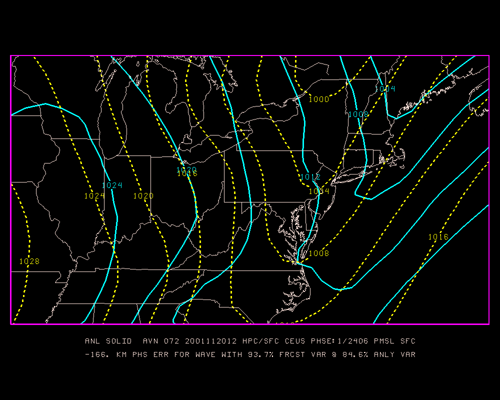
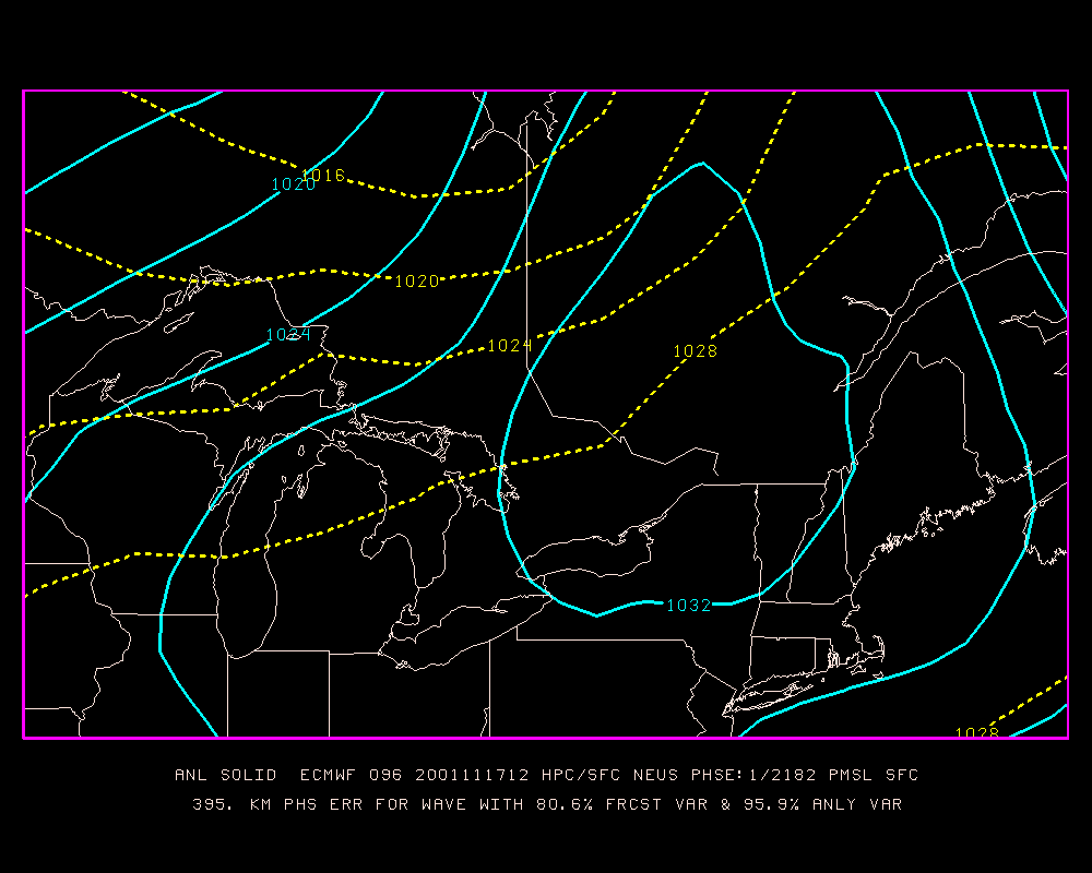
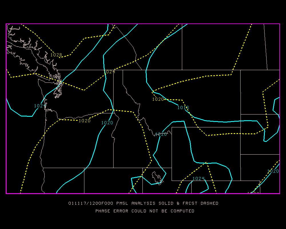
Three figures are presented as examples of results of the phase error calculation. Each figure shows the analysis of the mean sea level pressure as solid blue contour lines and the forecast as dashed yellow lines. The caption at the bottom of each figure gives the verifying year, month, day, and hour along with the forecast hour, the name of the model, the phase error, and the percentage of variance associated with the fundamental wave for which the phase error was determined for both the forecast and the analysis. Fig. 1 is a 72-h forecast from the NCEP global model showing that a trough exiting the eastern US is predicted to lag behind the observed position; hence, the phase is error is -166 KM, a negative value. This band is the Central Eastern US zonal band averaging about 2400 KM in length. The amplitude of the fundamental wave of that wave length accounts for 93.7% of the forecast field variance and 84.6% of the analysis variance on that bounded zonal band, after meridional averaging. Fig. 2 is a 96-h forecast from the European Center global model showing a high pressure cell that the model is too quick to move off the northeastern US coast. In this case, the forecast is too fast; so, the phase error is +395 KM. This zonal band is the North Eastern US band having a length of almost 2200 KM. The variance information is shown on the figure caption. Fig. 3 shows a verification on the North Western US band for which no phase error can be computed. The spectral decomposition for the analysis field differs too greatly from that for the forecast field.
In the NCEP/HPC application of this method, the following information is saved along with the phase error result:
Various types of displays are generated in the HPC for assisting forecasters. Time series of phase errors are presented for both forecasters and models. Average positive and negative phase errors are displayed separately along with data counts to show which sign of phase error predominated. The average net phase error is also presented. The averaging period is arbitrarily set at 84 days. These averages are presented for each zonal band for both models and forecasters.
There are several things HPC forecasters must keep in mind when looking at individual phase errors. There are times when the phase error cannot be computed because the forecast and analysis have different spectra. Therefore, there will be gaps in time series plots. The values computed are "raw" phase errors not corrected for the degree to which the spectral component with which it is associated contributes to the total variance. The phase errors may be more like those computed using the traditional manual method during the cold season when the synoptic wave pattern is better defined.